While sitting at home feeling sorry for myself with summer flu, I’m filling in time between coughs and sneezes by learning how and why to use waypoints (step by step route markers) for my DJI Mini 4 Pro drone.
What are Waypoints?
The waypoint system built into the DJI RC2 controller (complete with screen) allows you to set points along a route including beginning, end and in between.
I refer here to the Why? Well, at my age, controlling the drone around a route that is still only partly formed in my head, panning and turning left and right, moving up and down all while adjusting the camera elevation (and possibly zoom) as well as ensuring I’m videoing only what I need so as to avoid editing huge video files – is of course DOABLE but I got it into my head that there must be a better way?
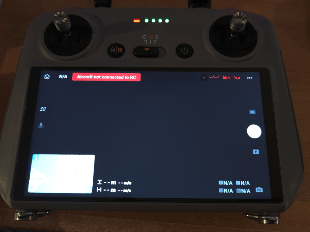
Trying to show you the RC2 screen is fun as at a decent exposure, the corner MAP is whited out. Here’s the controller. You should see some information, not much as the drone is disconnected… but on the bottom left of the screen which normally shows the drone live image, is a map. Once a drone is connected, the map will auto-locate – but it can be set manually – and can also be expanded to cover the whole screen when needed.

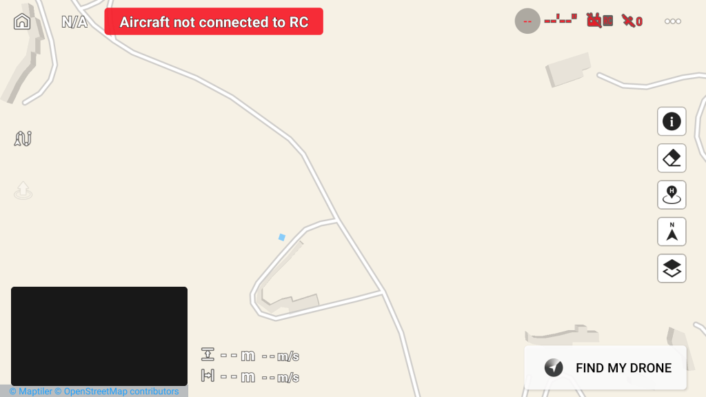
Below you’ll see an actual screenshot and I’ve expanded the map to full screen merely by clicking on it, leaving in the bottom left what will be the live drone video when one is connected. Clicking on that dark rectangle will restore the view to normal.

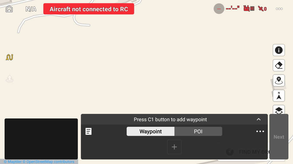
But while we are here, notice above left that zigzag icon on the left above centre, by touching that zig-zag you open the waypoint/poi (point of interest) dialog. At that point the wiggly line turns yellow.

Above we see the dialog ready go. You can look at a previous set of waypoints (a route) (white box in the dialog, left – 3 horizontal lines) without having an aircraft connected but it’s easier if the aircraft, in my case the Mini 4 Pro, is connected. So I’m sitting in my office in front of the DJI RC2 controller (which includes screen but the principle is not specific to this controller) looking at a map of our “street” in a hilly, rural part of Southern Spain – and I thought – for starters I’ll plot a route from our house to the end of the road, via the roundabout just down from our house. Our house is “Bedrock” and shows near enough in Google Maps – a plus as I can’t describe HOW rural we are – i.e. in the middle of no-where.
So in the image, right, you’ll see Bedrock at the far left and I want to plan a simple test trip via the roundabout to the far right of that image using a set of waypoints (just as a starting example). First hurdle, Google maps in default view has no idea we have a roundabout. On the drone, the map can see our tiny roundabout – but with no height information. Google Maps on the PC while selecting LAYERS at the bottom corner again shows the roundabout but no road height compared to our house entrance. This is where Google EARTH comes in. I hope this makes sense.. See image below..

In above image – our house is shown as “Scargill Tech” on the left instead of Bedrock as in Google Maps – you’d never think the same company made both of these mapping systems. Follow that Calle Ceuta road up and right to the end which is the top of our hill.
Why is any of this relevant? Because – the drone software does not automatically compensate for hills – and videos out there tend to concentrate on relatively flat areas. If I plot a nice route from our house to the top right of that image i.e. the junction… all great but check out this next image…

I chose as my starting height 25m to avoid annoying anyone. So with some REALLY simple button pressing on the map on the controller, I’ve made a route from our house (waypoint 1) to the end of the road (waypoint 7). For clarity, the drone will fly a smooth path from 1 to 7 when I press GO.. and note on Waypoint 7, I ‘ve set the camera to turn around to face home (arrowhead to the left edge of waypoint 7 faces the other way to the rest of the waypoints). I also set the video recording to start at waypoint 1 and stop at waypoint 7. All of this in my office with the drone on standby all this time – not actually doing anything – indeed it probably didn’t actually need to be turned on at all. Total planned flight distance 180m. At any time I can go in and edit any of those waypoints then save the lot for future use.
All very good but for two things… the height shown in the image above was set by me originally to be 25m above our house entrance road – and the height in the image above only changes to accommodate the valley in the middle because I manually did that – otherwise it would be the same height throughout – relative to my HOME, not the location under the drone. Wow. Sadly the road ISN’T the same height throughout – as the middle is several metres lower than the start and end.
The collision-avoidance software would stop the drone ending up in danger (and in this case the middle of the flight is in a a valley, not over a hill) but I really wanted the drone to follow the terrain height – enter Google EARTH which, given a point on the map,WILL HAPPILY show the exact elevation of that point on the bottom right of the screen – so some simple subtraction allows me to specify for any waypoint, the exact height above sea level of that surface.
That alone was a comprehension game changer for me… reducing the chance to zero of a random passer-by getting annoyed by the drone sound – my only remaining issue was EASILY altering each waypoint position to keep the drone over the road. It’s not trivial using a large finger on the controller.
My NEXT eureka moment was realising that I have a spare BT mouse and that the controller has BT, normally turned off in the settings – so I turned it on and paired the mouse to the controller. NOW I can in theory adjust those waypoints like a pro…
See waypoint 4, I just precisely moved it off the road temporarily using the mouse. Wheee. Had I kept this setting I’d have used my newfound info to adjust the height for that waypoint as that is not flat land.
In case this all sounds a little abstract -my first drone flight over a particularly huge lake in our area could have ended up in disaster with my previous DJI Mini 2 quite some time ago. Down at the beach near the water’s edge I started the drone up and sent it around the lake manually at 10m above the water. Great – and on its return I sent it all the way up the hill to an empty car park at the top to land at what I thought was a safe height to avoid trees.I just HAPPENED to notice that by the time the drone reached the top – it was no longer anywhere near 10m above ground level and was only JUST high enough to clear the high trees…. I’d just ASSUMED the drone would adjust height along the way to keep the same distance above ground – erm, no.
Now, if DJI are looking in, is there any way you could add an option to dynamically adjust the height of the drone relevant to the ground under the drone? Good usage example? Maybe you start by setting the drone to stay safely below or above any pylon cables? The anti-collision code would stop the drone accidentally hitting a pylon, but thin actual cables are often missed by both cameras and eyes…
Knowing all our rural pylons are the same height, knowing the exact cable height above ground and avoiding that height could be another game changer.
And for my LAST revelation for now, yes, Google EARTH on the PHONE also shows actual elevation… a bit more useful when you’re out and about.
I hope this is useful to someone. It has ramped up my confidence marvelously. Yesterday I was still getting to grips with waypoints would you believe.


